The Conflict Pre-Warning (CPW) Use Case explores the concept of Climate Security with a scenario, developed in the Sahel region, providing ad-hoc products supporting decision-makers. Heterogeneous data belonging to GEM data lake (and beyond) were integrated creating an adjustable datacube. The datacube, through a drill-down approach, was used to generate different products at different scales:
- In a first step, wide subcontinental (Sahel area) automated continuous monitoring at coarse resolution was implemented to predict high risk conflict areas (Fig. 1);
- In a second step, country scale products were generated in hot spot areas (e.g. Niger), based on the outcome of the first analysis (Fig. 2);
- In a third step, higher resolution data were used to perform ad-hoc analyses on local events, which support the generation of change maps, impact assessments or contingency plans (Fig. 3).
The CPW pilot showcased how the methods developed within GEM enable institutions such as SatCen to move along these axes, enabling performing an ad-hoc continuous monitoring over large areas of the world in a cost-effective manner and in a pro-active way, allowing them to identify the hot-spot areas to be monitored (e.g. with higher resolution satellite data).
An interactive storymap was created to present the outcomes of the CPW use case, allowing users to become familiar with the approach and the different data used.
Moreover, Jupyter Notebooks with guided exercises are available at the following link:
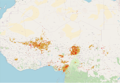
Figure 1: Predicted High risk conflicted areas (orange) and presence of conflicts (red)
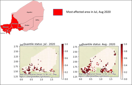
Figure 2: Anomalies of flooding in Niger during 2020 (red pixels)
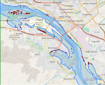
Figure 3: Local analysis with flood mask (blue) and building affected (red)
